at a glance
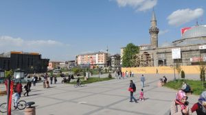
Erzurum is located in the Eastern Anatolia region. It is bordered to the east by Ardahan, Kars, Agra, to the west by Erzincan, Bayburt, to the north by Rize, Artvin, to the south by Mush and Bingöl provinces. With an average altitude of 1,853 meters, it is the fourth largest province in Turkey in terms of area. It's related. Seventy percent of their land is in the Eastern Anatolia region, and thirty percent is in the Black Sea region. The highest point of the city, which has a mountainous terrain, is Dragon Hill at 3,176 meters.
Erzurum, the eastern gate of Anatolia, has been a vibrant center throughout history because of the military and commercial importance of its location. Its economy, which was occasionally shaken by the wars in the region, was influential in achieving significant commercial vitality during the Ottoman period. Its location on the historic Silk Road was one of the activities that positively influenced trade, enabling the transport of commercial products from Asia to Europe. Thus, it became an important tax center of the time of Erzurum due to the customs duties collected from the import and export market that entered and exited. According to Evliya Çelebi, who served in the Erzurum customs, this was the place where trade was most lively after Istanbul and Izmir.
The first known indigenous people of the city, who also have a rich archaeological deposit, are the Urartians; this information has been obtained from vessels and pottery obtained in excavations on the hills of Karaz and Pulur. This was followed by the Persians, the Romans, the Sassanids, the Emevi, the Byzantines and the Turks. Her first name is Karin. Between 415 and 422 AD, the Byzantines founded a city in the west of Erzincan against attacks from the east and named it Theodosiopolis.
It was called Karin by the Armenians, Theodosiopolis by the Greeks, Erzen by the refugees. Not to be confused with Erzen in Iran, it was called Erzen-i Rum and eventually took its current name, Erzurum.
Travel Plans

Accomodation


Where to eat


